3.1.6 Profile View
The side view is a useful 2D visualization that displays the terrain's elevation and the airspaces along the planned route of the flight plan or the current direction of flight. Furthermore, in the side view you can also set the altitude at which you plan to intercept a specific (way-) point of the flight plan.
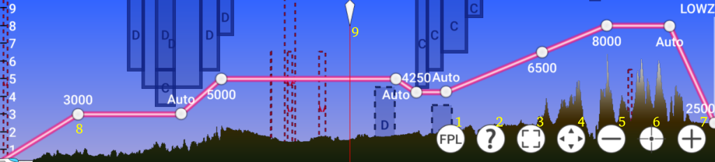
(1) Indicates that flightplan mode (profile view along flightplan) is active. Click to switch to vertical situation mode (profile view along current direction of flight).
(2) Opens this help.
(3) Switches to fullscreen
(4) Switches to extended view (larger portion of screen is occupied but not fullscreen, useful in combined usage with Moving Map).
(5) Zoom out
(6) Center / reset zoom
(7) Zoom in
(8) Drag and drop a waypoint vertically to set the desired altitude at that point. By default the altitude is set to "Auto". This means the altitude is automatically derived from the previous waypoint. To return to the "Auto" state after defining an altitude simply swipe the waypoint horizontally. New waypoint can be created using drag and drop in the Moving Map.
(9) Swipe across the profile view to change the center position in the Moving Map. This way it is easy to follow the flightplan.