Moving Map Render Options
The 2D Render Options define various settings for the 2D Moving Map. They are stored inside the "Custom" Profile (see Menu -> Setup -> Preferences). Changing these settings causes automatic switching to the "Custom" profile.
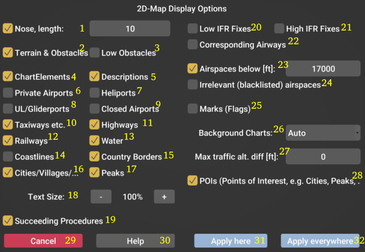 |
(1) Length of the distance indication at the nose of the miniature aircraft in NM. (2) Show terrain and obstacles (3) Show obstacles even if they are irrelevant based on the current altitude (4) Show chart elements (e.g. airports, airspaces, etc ...) (5) Show short descriptions / names of chart elements (6) Show private airports (7) Show heliports (8) Show small airports usually used for gliders or ultralight/LSA/experimental aircraft (9) Show closed airports (10) Show taxiways (zoom in required to see them) (11) Show highways (12) Show railways (13) Show water (lakes, rivers, etc) (14) Show coastlines (15) Show country borders (16) Show city names (if POIs enabled, see 28) (17) Show peak names (if POIs enabled, see 28) (18) Increase / decrease text size of labels (19) Show the whole flight plan (not just the current procedure) (20) Show low ifr fixes (usually depicted in a low ifr chart) (21) Show high ifr fixes (usually depicted in a high ifr chart) (22) Show airways connected to the high or low ifr fixes (23) Show airspaces below the limit (for decluttering) (24) Show blacklisted airspaces (classes / types from blacklist in "General Setup") (25) Show marks (no important information) (26) Choose the backround / raster charts if installed (Auto: automatically show raster chart if installed) (27) Decluttering of traffic information: Only show traffic if altitude difference is lower than selected (0 = disabled) (28) Show POIs like water body labels, country labels, cities, peaks, ... (29) Close the options menu without saving changes (30) Open the help (31) Close & apply changes to this Moving Map only (32) Close & apply changes to all Moving Maps on all pages |